Kallang Basin:
The Thread That Binds Singapore
Kallang Basin has witnessed the development of Singapore in different stages. Many prominent landmarks existed at Kallang, such as Kallang Airport, the old National Stadium. Besides, Kallang Basin was one of the most industrial prosperous areas in Singapore mainly for light and medium industries in the last century. The Kallang Basin has been playing a vital role in connecting people and cultural heritage and awakening people’s memories about the old days.
The Past
The name Kallang had appeared as early as 1835, in a map drawn by George Dromgold Coleman (1795-1844), an Irish architect, planner and surveyor of early Singapore.
Prior to extensive land reclamation along Singapore's southeastern coast, the Kallang River used to empty into the Singapore Straits at the Kallang Basin, near where Merdeka Bridge is standing.

The Orang Kallang were among the indigenous inhabitants of Singapore. They constituted half of the approximately 1,000 residents in Singapore at the time of Raffles’s landing in January 1819. The Orang Kallang were boat-dwellers who lived in the swamps at the mouth of the Kallang River, which was named after the community.
Historically, the basin also provided a sheltered inlet where ships could anchor and was significant for shipping from the earliest days of modern Singapore. According to an account from the Cho Clan archives, this was where Sir Stamford Raffles first set foot on the island. By 1822, there were marine yards on its shore and it became an important centre for shipbuilding over the years.
When Singapore was ceded to the British in 1824, the Temenggong of Johor relocated the Orang Kallang to Pulai River in Johor.

"In the early 1930s, extensive filling and reclamation took place in Kallang for the construction of Singapore’s first international airport."
In the 20th century, buildings began to be built in this area which originally had were abattoirs.
Possibly the first brickworks were found on the left bank by 1835. By the late 19th century there were sawmills, oil and rice mills, abattoirs, engineering workshops and factories. The Kallang Gasworks were constructed in 1860 and continued to operate until 1988.
In the early 1930s, extensive filling and reclamation took place in Kallang for the construction of Singapore’s first international airport. Completed in 1937, the Kallang Airport was in operation for some 18 years. It was replaced by the Paya Lebar Airport, which opened in 1955. The former airport building, and part of the premises subsequently became the headquarters of the People’s Association.
In 1936, the Happy World (later renamed Gay World) Amusement Park opened in the area between Mountbatten and Geylang roads. Nicoll Highway, the first shortcut from the East Coast to the city, was completed in 1956. Adjoining the highway is the Merdeka Bridge, which had two lions at both entrances to commemorate Singapore’s struggle for independence.

Figure 2: 1945 Map of the Kallang Basin Area
In the 1950s, Kallang Road was the main road between urban areas and eastern suburbs. With the increasing population of Singapore, more and more people had to move to remote areas in the eastern part of the island. To relieve the traffic on Kallang Road, the Merdeka Bridge which connects the urban area with the east coast began to be built.
In 1956, the Merdeka Bridge was opened to traffic, with a total length of 610 meters, connecting Nicoll Highway and Kallang Airport. The Merdeka Bridge is the first bridge built after the Japanese War. It is named after Malaya's independence in 1957. The Merdeka Bridge symbolizes the Singaporean people's lofty sentiments of getting rid of colonial government rule and striving for independence and nation-building around the world.

The Present
Post-Modern Narrative
At present, many conserved areas and historic buildings exist in Kallang basin, such as Little India, Kampong Glam and so on. As the Kallang Basin has been playing a vital part in connecting people and cultural heritage and awakening people’s memories about the old days, it presents rejuvenation opportunities for new homes, workplaces, recreation, and community spaces.
In 1977, a solution was proposed with the draft plan to clean up the Singapore and Kallang Rivers. The farms, industries, shipyards, and shipping were gradually removed from the area. Pig and duck farming persisted until the 1980s, and shipyards until 1992. A plan to build a dam across Marina Bay was announced in 2004.

Figure 3: Marina Barrage
The dam, known as the Marina Barrage, was completed in 2008, turning the Kallang basin and Marina Bay into a freshwater reservoir, and cutting off access to the sea. This reservoir is now used for water sports and other recreational activities, as well as water taxis, but waterborne activities are controlled to maintain water quality, since the reservoir is one of the sources of drinking water for Singapore. The waters of the Kallang Basin are currently part of the reservoir described above. It is used for recreational activities but - having been cut off from the sea - it has lost its historical function. It is now a valuable public amenity with possibilities for future development.
However, the maritime, agricultural and industrial heritage is now largely a memory with little in the landscape or built heritage to remind us of the past - apart from the old Kallang Airport, which does have significant potential for development as a heritage site.
The Future
What's next for Kallang Basin?
With its route winding through the central region of Singapore, both public and private housing will be introduced in precincts along Kallang Basin to enjoy the great connectivity. The existing Kallang Industrial Estate will also be transformed in the longer term into an attractive mixed-use precinct along the waterfront.
As efforts are being made to improve connectivity, the river too will be made more scenic for nearby residents and visitors.

Several stretches of waterways at Upper Boon Keng Road to Sims Avenue, Potong Pasir, and Kolam Ayer have been given a facelift through the PUB’s Active, Beautiful, Clean Waters projects. Other stretches along Kallang River are also being studied for such improvements. At the ‘Kallang Alive!’ Sports Hub area, Sport Singapore is introducing more sporting and community facilities to strengthen its standing as an inclusive sporting precinct.

Figure 4: Main Conserved Areas in Kallang basin

“Through historical investigation and cultural mapping, this study is an attempt to bring forward and justify the significance of the Kallang Basin."
The nearby conserved Old Kallang Airport can also be put to a variety of community, sports and recreational uses for all to enjoy. More intermediary habitats can also be provided along the river for biodiversity and wildlife to thrive.
Conserving tangible and intangible heritage is an important part of Singapore’s development and urban planning. The restoration of historic areas adds variety to our urban fabric and creates visual contrast in the city, while helping to rejuvenate dilapidated areas into thriving districts, and conserved buildings hold continued relevance in today’s context. Through historical investigation and cultural mapping, this study is an attempt to bring forward and justify the significance of the Kallang Basin. Other than that, suggestions on how that significance can be or should be retained is also brought to light.

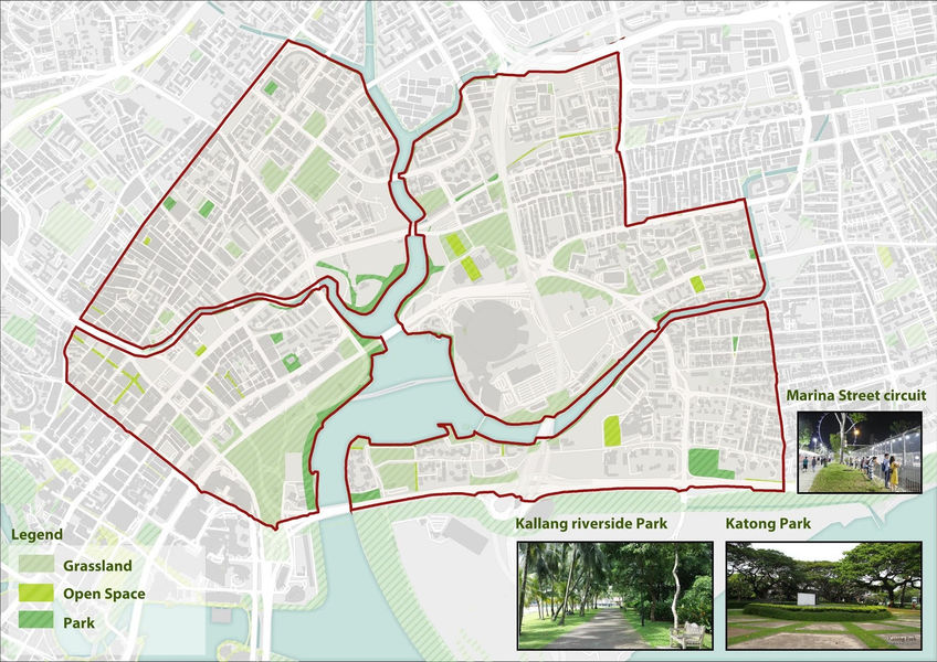
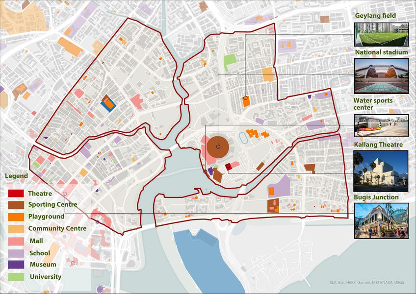
Figure 5: Areas of Study
According to URA’s 2019 plan, in the longer-term, the larger area around Kallang Riverside will be developed into a mixed-use lifestyle hub. In the interim, the conserved old Kallang Airport area will first be made available for a variety of sports, leisure and community uses. Looking back to the evolution of Kallang Basin, it has a robust collection of buildings and places including functions for entertainment, commute, monument, etc. Learning from the prosperity and decline of the past and understanding the deep-down reason can help shape draft plans to support the rejuvenation of Kallang District.
Furthermore, respect and admiration for ancestors can be raised among younger generations due to the dig-in process of the old district and neighbourhood. Our suggestions for the plan's proposals should be incorporated where appropriate and be considered as the authority develops detailed plans for future areas, allowing planners to update on the actions taking prior to sense of belonging and placemaking.
Bibliography
[1] https://www.ura.gov.sg/Corporate/Get-Involved/Plan-Our-Future-SG/Kallang-River
[2] http://www.nas.gov.sg/blogs/offtherecord/introduction-to-the-national-archives-of-singapore-map-collection/


